The Tidal Imprint: How Hydrological Rhythms Forged the Urban Spacing of Vietnam’s Mekong Delta
by Juan Inoriza
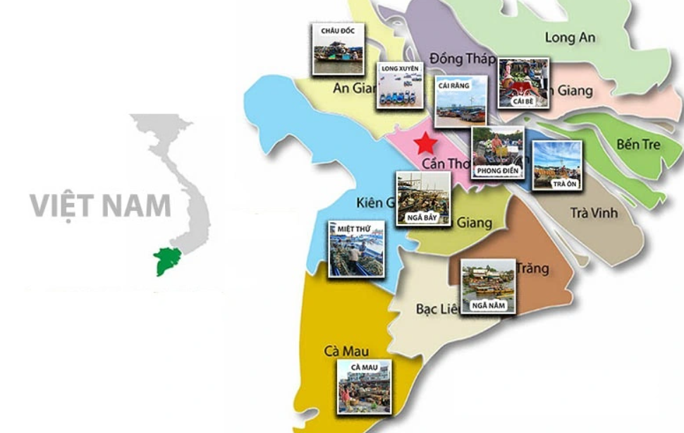
The Mekong Delta, a vast aqueous expanse of emerald rice paddies and labyrinthine waterways, presents a remarkable geographical phenomenon: the strikingly consistent spacing of its major urban centres. Châu Đốc lies approximately 60 kilometres from Long Xuyên, which is in turn 60 kilometres from Cần Thơ, itself 60 kilometres from Sóc Trăng. This evenly distributed pattern, which repeats across much of the delta, is far from coincidental. It stands as a testament to the historical interplay between human settlement and the region’s hydrological conditions—specifically, the rhythm of the tides.
Tidal Rhythms and Riverine Transport
The origins of this spatial configuration can be traced to the delta’s traditional dependence on waterborne transport. In the pre-modern period, before the advent of extensive road infrastructure, the rivers and canals of the Mekong Delta functioned as the principal arteries of movement and commerce. Boats and canoes were indispensable for both short- and long-distance travel across the low-lying, flood-prone terrain.
Crucially, travel was synchronised with the tidal cycle. The Mekong experiences four significant tidal shifts daily, alternating roughly every six hours between high and low tides. Given an average river flow of approximately 10 kilometres per hour, boats could typically travel 60 kilometres within the six-hour tidal window. When the tide reversed, voyagers were required to halt and await the next favourable current. These pauses became natural points of congregation and exchange—sites that would, over time, evolve into permanent settlements.
Floating Markets and the Genesis of Urban Centres
At these tidal junctures, the Mekong Delta’s iconic floating markets emerged. These were not simply temporary trading posts but vibrant economic and social hubs. They facilitated the exchange of agricultural produce, fish, and goods between rural communities and itinerant traders. The growing frequency of exchanges generated demand for support services—such as boat repair, storage, fuel, and food—which led to the establishment of more permanent facilities on the adjacent riverbanks.
As these informal service clusters grew, they became anchored into the landscape, transforming into towns and eventually major urban centres. This process of sedimentation—both literal and figurative—produced cities such as Châu Đốc, Long Xuyên, Cần Thơ, and Sóc Trăng. Each owes its origin, at least in part, to its position at a point where tidal conditions compelled boats to stop, trade, and rest before continuing on the next leg of the journey. In this way, hydrology imposed a kind of spatial logic upon the landscape—one that persists in the region’s urban geography to this day.
A Distinctive Model of Settlement
This pattern of development is exceptional when viewed in comparison to other deltas around the world. In many cases, urban centres developed around overland trade routes, defensive positions, or nodes of agricultural productivity. The Mekong Delta, however, is characterised by a mode of settlement that is fundamentally aquatic. The distribution of towns at roughly 60-kilometre intervals is not the result of administrative planning or geometric design, but the consequence of the natural pace set by tidal currents.
This distinctive rhythm differentiates the Mekong from deltas such as the Nile or the Mississippi, where urban settlement patterns correlate more closely with overland transport or natural confluences. In the Mekong, by contrast, the river itself dictated not only where people could move but also where they would stop—and eventually, where they would stay.
Modernisation and Changing Currents
The contemporary transformation of transport infrastructure has dramatically reshaped this dynamic. The construction of bridges, roads, and motorways, alongside the widespread use of motorbikes and lorries, has gradually diminished the centrality of riverine navigation for both local and interprovincial travel. Floating markets, once the economic lifeblood of the delta, have declined in both number and significance. Some, such as those in Cái Răng and Phong Điền, continue to operate, though often more as cultural attractions than as commercial necessities.
With modern land transport offering greater speed, flexibility, and connectivity, the need for tidal-timed exchanges has lessened. Nonetheless, the spatial legacy of these earlier patterns remains inscribed on the delta’s geography. The uniform distribution of cities continues to reflect the historical interplay between tide, travel, and trade. The former navigational necessity has become a fixed feature of the regional landscape—a geographic memory embedded in the fabric of urban Vietnam.
Conclusion: An Enduring Hydrological Legacy
The consistent 60-kilometre spacing between major cities in the Mekong Delta stands as a remarkable legacy of an era when human activity was inextricably tied to the ebb and flow of the river. It illustrates the capacity of natural forces—specifically the rhythms of water—to structure patterns of human movement and settlement. What began as a pragmatic adaptation to tidal dynamics has solidified into a lasting urban imprint.
As the Mekong Delta continues to modernise and adapt to new economic realities, this distinctive settlement pattern remains a powerful reminder of the intimate and evolving relationship between human societies and their natural environments. The legacy of the floating markets, etched into the space between towns, preserves a vital chapter in Vietnam’s cultural and historical narrative.
References
Chapuis, O. (1995). A history of Vietnam: From Hong Bang to Tu Duc. Greenwood Press.
Cosslett, T., Cosslett, P. D., & Cosslett, R. L. (2013). Sustainable development of the Mekong: Issues and responses. Springer.
Garschagen, M., Diez, J. R., Nhan, D. K., & Kraas, F. (2012). Socio-economic development in the Mekong Delta: Between the prospects for growth and the pressures of modernisation. In F. G. Renaud & C. Kuenzer (Eds.), The Mekong Delta system: Interdisciplinary analyses of a river delta (pp. 83–132). Springer.
Lê, A. T. (2023). Interview with the Vietnam National Television Channel (VTV) on the hydrological origins of urban spacing in the Mekong Delta. [Broadcast interview].
Nguyen, V. H. (2011). From floating markets to fixed towns: A cultural geography of settlement in the Mekong Delta. Vietnam Social Sciences, 4(134), 33–47.
Nguyen, Q. M. (2014). Water and identity: Cultural practices and hydraulic knowledge in the Vietnamese Mekong Delta [Doctoral dissertation, University of Oslo].